ESSO Annuitant Hiking Club
|
Trail name(s): |
Pocaterra Ridge / Little Highwood Pass / Ptarmigan Cirque |
|
Hike Date: |
July 13 2017 |
|
Trail Planner: |
Janet Barker |
|
References: |
Kananaskis Country Trail Guide, 4th Edition – Daffern; Gem Trek Kananaskis Lakes |
|
Trail Access: |
Highwood Pass Day Use Area |
|
Washrooms |
Mt Kidd RV Park / Highwood Pass Day Use Area |
|
Notes: |
B2’s have option of Little Highwood Pass (with B1s) or Ptarmigan Cirque (with Cs) |
|
Hike Summary |
A1 |
A2 |
B1 |
B2 |
B2(alt) |
Cs |
|
Total Distance (km.) |
9 |
9+ km |
8.6 |
8.6 |
4.5 |
4.5 |
|
Elevation Gain (m) |
950 m gain 640 m loss |
450+ |
472 |
472 |
225 |
225 |
|
Equiv. Flat Distance (km.) |
18.5 |
13.5 |
13.3 |
13.3 |
6.8 |
6.8 |
|
Difficulty Rating |
Diff |
Diff |
Mod |
Mod |
Easy |
Easy |
|
Group |
Km. |
Elev. |
Route Description |
|
A1/A2 |
0.0 |
2206 |
Pocaterra Ridge Start at the Highwood Pass Day Use Area along Highwood Pass Meadows interpretive trail. After a short distance, turn left onto an unsigned single-track trail running down the centre of a grassy channel. Reach a large rock at a bottleneck – trail turns off left into the trees. After crossing a tiny creek, climb up ridge through open spruce. Near the 1st high point, find 2 smaller trails heading off to the left to Highwood Ridge – keep right |
|
1.0 |
Trail descends slightly, heading for Pocaterra Tarn. At bottom of hill, a 3rd trail left again heads for Highwood Ridge – keep right. Main trail climbs briefly to a 2nd high point below a rock band marking the ridgeline, then makes a long, twisty descent with some steep shaley steps, before levelling out & crossing an avalanche slope. Next the trail climbs a bit, then descends in zigzags to a fork of Pocaterra Cr. Climb up the left bank, then cross to the right bank before the creek goes below rubble. |
||
|
2.0 |
Pocaterra Tarn – follow trail along boundary between scree & larches, eventually turning right into a large flat meadow at the forks of Pocaterra Cr. Continue to a trail jct. marked by a rock & turn left. |
||
|
Trail leaves the meadow & climbs between larches, then traverses a grass slope to a T-jct. below the high wall of the moraine. |
|||
|
|
2.9 |
Turn right at the T junction. Trail heads into a grassy draw below the moraine wall. Follow draw to end, keeping left where old route joins in. Trail climbs onto a rib above N. fork of Pocaterra Cr. Continue to base of wall, then descend to creek bed. Valley makes a sharp right turn, giving the 1st view of Little Highwood Pass. Continue up enclosed valley towards pass. |
|
|
4.0 |
|
Turn right and head up broad south ridge to gain the first peak of Pocaterra Ridge. |
|
|
4.4 |
~2650 |
From the southernmost (and highest) peak, continue along ridge as far as time and energy allow. A1’s can continue north to be picked up at the Little Highwood Day Use Area. |
|
|
A2 |
9+ |
|
Return to Highwood Pass Day Use Area using the same trail. |
|
Group |
Km. |
Elev. |
Route Description |
|
B1/B2 |
0.0 |
2206 |
Little Highwood Pass Follow A route to the turn-off at 4.0 km. At this point, continue straight ahead to the pass. |
|
4.3 |
2545 |
Little Highwood Pass – stop for lunch & enjoy the view before retracing route back to parking lot. |
|
|
8.6 |
Highwood Pass Day Use Area |
|
Group |
Km. |
Elev. |
Route Description |
|
Cs B2(alt) |
0.0 |
2206 |
Ptarmigan Cirque Start at the Highwood Pass Day Use Area and head along Highwood Pass Meadows interpretive trail. |
|
0.4 |
Turn right, just before boardwalk, and cross highway. |
||
|
1.3 |
Trail fork – go left & tour the cirque in a clockwise direction. |
||
|
2.25 |
2420 |
Head of cirque loop, & trail high point. Pick a lunch spot, & enjoy the view before continuing clockwise tour. |
|
|
3.7 |
Turn left at fork & follow trail back to Parking Area. |
||
|
|
5.0 |
Highwood Pass Day Use Area |
|
Prepared by: |
Gord Dobson |
|
Preparation Date: |
2011/0723 |
|
Edited by: |
J. Barker |
|
Edit Date: |
2017-06-09
|
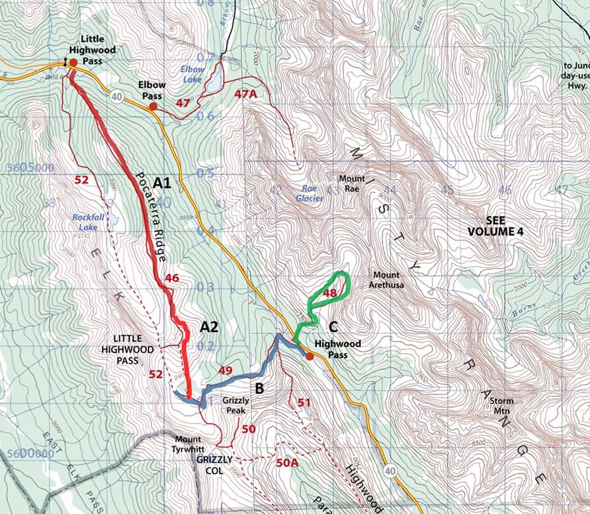
Trail Map