ESSO Annuitants’ Hiking Club
|
Trail name(s): |
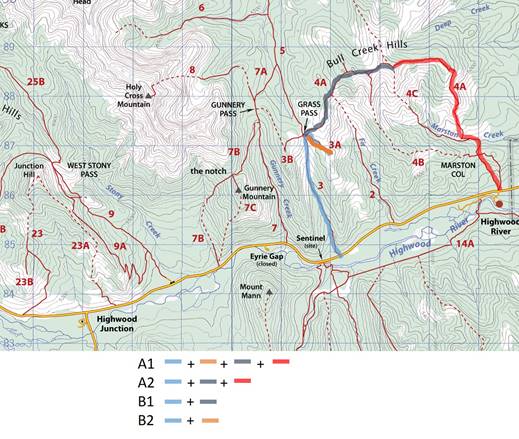
Bull Creek Hills/Grass Pass/Highwood Beaver Ponds |
|
Hike Date: |
June 8, 2017 |
|
Trail Planner: |
Janet Barker |
|
References: |
Kananaskis Country Trail Guide (Daffern) Volume 5, Hikes #4,3 & 50 |
|
Trail Access: |
A, B: Hwy 541 via Longview, 3.5 km past large K Country sign C: Hwy 940, immediately south of bridge crossing the Highwood River (look for orange “Caution Cattle at Large” sign |
|
Washrooms: |
Longview Rest Area |
|
Hike Summary |
A1 |
|
A2 |
|
B1 |
|
B2 |
|
C |
|
Total Distance (km.) |
12.2 |
|
10.2 |
|
9.4 |
|
7.8 |
|
8.0 |
|
Elevation Gain (m) |
878 |
|
878 |
|
716 |
|
450 |
|
100 |
|
(Equiv. Flat Distance (km.) |
21 |
|
19 |
|
16.5 |
|
12.3 |
|
9.6 |
|
Difficulty Rating |
Mod/Diff |
|
Diff |
|
Diff |
|
Mod |
|
Mod |
|
Group |
Km. |
Elev. |
Route Description |
|
A1 |
0.0 |
1450 |
Trail starts on north side of highway, leading into Pack Trail Coulee. Continue up the valley through some old giant Douglas fir, over a small creek and onto grassy meadows. |
|
|
2.8 |
1875 |
Just before the pass is a star-like junction with some options. |
|
|
5.0 |
|
A1 side trip: Take first trail to the right to go southeast on to Fir Creek Point and out to the Boundary Pine (about 2 km round trip). Back track to the star-like junction and continue eastward about 3 km along the ridge above Fir Creek Valley. |
|
|
6.7 |
2179 |
There are minor summits along the ridge before the main summit of Bull Creek Hills (Peak #4 in Daffern’s book). Continue east and south to Peak #5. |
|
|
9.2 |
2051 |
Descend to Marston Col and then out to highway. |
|
|
12.2 |
1450 |
Return to the highway across from the Highwood Day Use area. |
|
A2 |
0.0 |
1450 |
Follow A1 route, omitting the side trip to Fir Creek Point. |
|
|
2.8 |
1875 |
At the star junction, take the second right to head east up a grassy ridge. |
|
|
4.7 |
2179 |
Main summit of Bull Creek Hills (Peak #4 in Daffern’s book). Great views. |
|
|
7.2 |
2051 |
Peak #5. |
|
|
10.2 |
1450 |
Return to the highway across from the Highwood Day Use area. |
|
Group |
Km. |
Elev. |
Route Description |
|
|
B1 |
0.0 |
1450 |
Follow A1 directions to Grass Pass. |
|
|
|
2.8 |
1875 |
Follow A2 route |
|
|
|
4.7 |
2179 |
Main summit of Bull Creek Hills (Peak #4 in Daffern’s book). Great views. |
|
|
|
9.4 |
1450 |
Return to highway on the trail you came in on. |
|
|
|
|
|
|
|
|
B2 |
00 |
1450 |
Follow A1 directions to Grass Pass. |
|
|
|
2.8 |
1875 |
Turn right and walk southeast onto Fir Creek Point. |
|
|
|
5.0 |
1863 |
Lunch stop at the Boundary Pine |
|
|
|
7.8 |
1450 |
Return to highway on the trail you came in on. |
|
|
|
|
|
|
|
|
Group |
Km. |
Elev. |
Route Description |
|
|
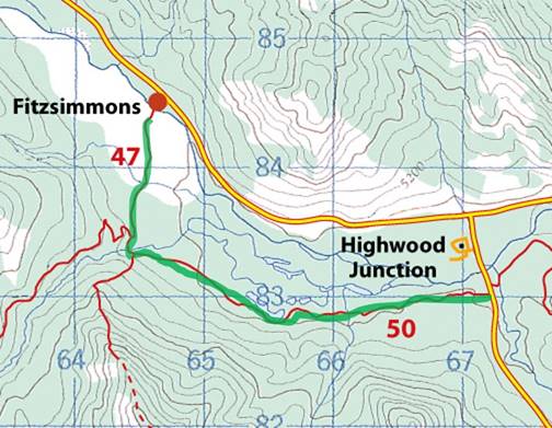
C |
0.0 |
1514 |
Access the trail on the west side of Hwy 940, near an orange “Caution Cattle at Large” sign. It starts as an easy walk on an old logging road. |
|
|
|
.8 |
|
Road narrows to a trail and makes a short, steep descent to a creek crossing. Note this crossing from the other direction; there is an overgrown logging road to ignore on the return trip. |
|
|
|
.9 |
|
Follow the trail past a willowy meadow, taking all possible bypasses on the left to avoid the mud. Watch out for roots on the trail. |
|
|
|
1.2 |
|
Go around a fallen spruce. The first beaver pond is on your right. |
|
|
|
1.4 |
|
Take right at Y junction for a better look at the pond. Return to the junction and take left fork to carry on. |
|
|
|
1.8 |
|
Stay left at junction to go to an open marshy area with more beaver activity. Great views to the north of Junction Hill. |
|
|
|
2.5 |
|
Cross a long meadow with a salt lick. Back in the forest the trail reverts to a logging road, passing a second salt lick. |
|
|
|
3.0 |
|
A small cairn on left indicates Coyote Hills trail. Continue straight. If it is possible to cross Fitzsimmons Creek, then do so, ducking under branches and climbing out to right of newly eroded bank (post 2013 flood). |
|
|
|
3.3 |
|
At a 4-way junction, continue straight (north) to head towards Fitzsimmons Day Use Area. |
|
|
|
4.0 |
|
Continue as far as the Highwood River crossing before returning to the trailhead on the same trail you came in on. |
|
|
|
8.0 |
|
Trailhead on Hwy 940 |
|
|
|
||||